
This is a well overdue post from me, especially considering it was supposed to appear to coincide with the designerlessons presentation on “Classroom Cartography” at the TESOL Spain event at UAB back in February! Still, better late than never, and I hope you find this lesson as fun and productive as I and my students have.
I have chosen the European map as the context for this lesson, but this can easily be changed as the Alphadesigner website, from which the maps below are taken, also includes maps of other continents. Moreover, as with a few of my lessons, there is a “bad” language warning, so please study the maps carefully before you offend anyone in your class!
Level: Upper Intermediate, Advanced, Proficiency (B2-C2); Adults
Lesson Aims
- To practise country names in English
- To develop the functions of speculation, summarising and distancing in relation to stereotypes
- To develop creativity
- To discuss the persistence of stereotypical views
- To deal with ‘whatever else comes up’ (the lesson provides lots of opportunities for emergent language)
Preparation
- Two printed maps of Europe per group of 3-4 students, with borders but otherwise blank (like this one)
- A completed European map for reference (like this one)
- Have selected maps from the Alphadesigner website ready to be displayed via a projector or on screen
- A printed copy of one of the European maps for each group – select a different map for each (or, if your students have smart devices and there is an internet connections, they could view the maps directly from the website)
Procedure
1. Put your students into small groups and give each one blank map of Europe. Set a time limit (say, 3 minutes) in which they have to name as many countries as they can – in English. (For any timed activity I like to use the online bomb timer – it usually adds a bit of impetus!)
I must say that my students did better at this than me – I struggle the further east we go. Anyway, it’s easy to feed back by having your completed map to hand or on screen, and it’s a great opportunity to check your students’ pronunciation of these country names. Often, by virtue of their similarity to English (for Spanish speakers at least), students have neglected to bother learning the difference.
2. Now tell your students that you have found a map of Europe with different names. Display the following on screen if you can – the chances are one of your students may have already seen a map like this, as they started doing the social network rounds last year. Anyway, give it a few moments to sink in.
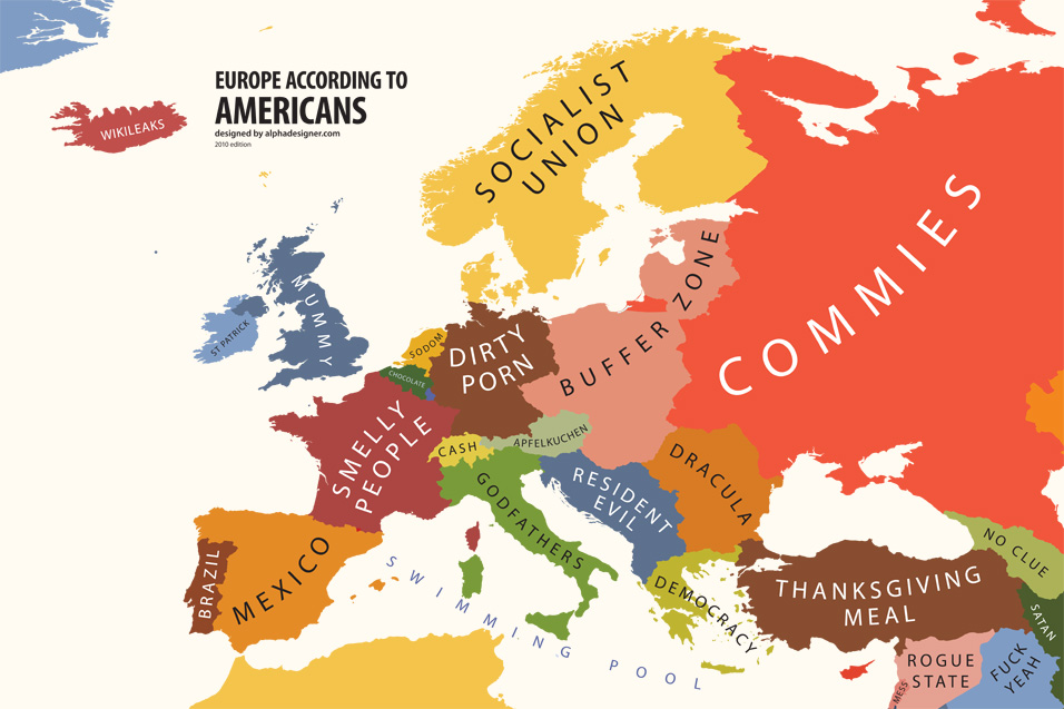
from http://alphadesigner.com/mapping-stereotypes/
Once the initial hubbub (and hopefully laughter) has died down, elicit the fact that this map represents stereotypes – that’s to say, popular but simplistic and inflexible representations of identity – from an American point of view. It also shows a stereotyped view of how Americans view Europe. Try some comprehension (and general knowledge) questions to get at the meaning of some of the names and their humour, e.g.
- What do Americans eat at Thanksgiving? (Turkey)
- Which country is described as a ‘rogue state’? (Syria) What could ‘rogue’ mean? (Badly behaved; breaking the rules)
- What could ‘buffer zone’ mean? Where are these countries situated? (Between the ‘commies’ and Western Europe, so a ‘buffer zone’ is a zone of protection between two distinct areas)
- Which countries are ‘resident evil’ on the map? (The former Yugoslav states) Who was the star of the Resident Evil movie? (Milla Jovovitch) What’s the connection? (Jovovitch is a Serbian name – the actress was actually born in Ukraine but her father is Serbian)
3. Next, put your class in pairs and ask them to discuss what this map says about how the Americans view Europe. You can point out that they do not have to agree with the picture this paints of Americans!
Possible answers
The Americans have an outdated view of Europe and are still obsessed with the cold war
They have a hazy grasp of geography
They tend to view things through the perspective of Hollywood
They may tend towards religious fundamentalism (“Satan” and “Sodom” representing Iran and Holland respectively)
As your students suggest answers, encourage them to justify their opinions in relation to the map and then summarise their position. This is a good opportunity to elicit or feed in some exponents of summarising:
S: Yeah, so they think a lot about movies, like Italy is Godfathers, Romania is Dracula, Yugoslavia is Resident Evil ….
T: So, what you’re saying is …?
S: What we’re saying is that movies dominate their culture
Other examples:
- Basically, they think they’re still at war with the Russians
- What it comes/boils down to is that geography lessons in the USA must be awful
- In a nutshell, they’re religious maniacs who watch too many movies and don’t study world geography!
Emphasise that all this is ‘according to the map’ – you may want to feed in additional phrases useful for distancing yourself from a point of view:
- They’re viewed as …
- The map shows/depicts them as …
- They’re characterised as being …
4. This may be a good opportunity to discuss with your students how fair or unfair they feel this portrayal of Americans is – or leave this until the final discussion stage.
5. Put your students back into their groups of 3-4 and give each group a different map from the site (or have them access the maps via their mobile devices, making sure they look ONLY at the map assigned to them). Firstly, they should discuss what the country names represent, then try to characterise the perspective of the country whose views the map represents. (The fact that these maps are not based upon any scientifically valid data regarding national perspectives does not, in my view, invalidate discussing them as if they did, although students should again be made aware of the purely subjective content presented in them.)
I chose to group my students – who are from Catalonia, Spain, Uruguay and Argentina – in such a way that they were not given maps which describe the perspectives of their own country or region. My first group discussed:
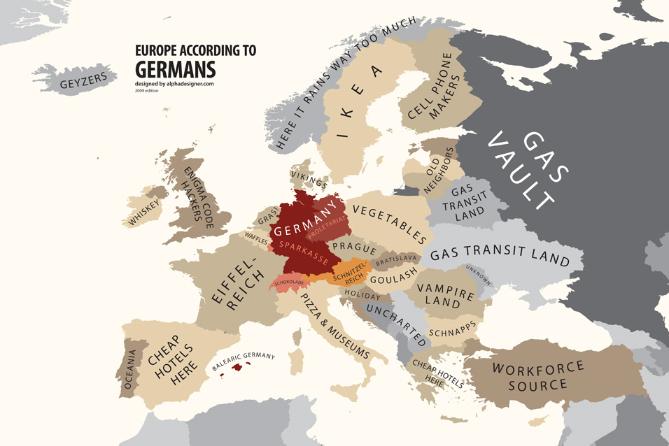
from http://alphadesigner.com/mapping-stereotypes/
Some points which may help with this:
- the Sparkasse is a German savings bank
- the Enigma Code was a code used by Nazi Germany during WWII
- Schnitzel is a typical German meat dish, and Reich refers to a realm
The second group had:

from http://alphadesigner.com/mapping-stereotypes/
Points to note:
- El papa chulo means “the cool pope” and refers to John Paul II; this epithet may now have been transferred to the Vatican’s latest resident
- Cuca Riot is a Latin American slang translation of Pussy Riot, the imprisoned Russian punk group
- Leididí refers to Diana Princess of Wales, or “Lady Di”
- La madre pútria is an untranslatable play on words which twists “motherland” into something seedy and rotten.
Throughout this discussion stage, take note of how your students are using the language of speculation. I have made it my mission this year to stop my students saying “It’s possible that ….”, an intelligible yet (to me) rather annoying translation that many Spanish-speakers employ in English. A little quiet direct feedback to groups mid-activity might be useful to focus your students on more typical modal phrases for speculation, or you may choose to delay feeding back on this and do more work on it later (did you see what I did there?)
6. Once everyone has had sufficient time to explore their maps and their implications, mix the students up so that one or more from each group is placed with one or more from each other group. Their task now is to describe and summarise their map to the others, with encouragement to use the phrases covered in stage 3. You don’t necessarily need to print more maps for this: if each group deals with a different map at a time, then moves onto the next more or less in sync, the student(s) whose turn it is can then retrieve the required map from one of the other groups. Use feedback as an opportunity to iron out any misunderstandings as well as to correct any significant errors from the previous two stages.
7. Now for the creative part. Put the students back in their original groups and give each one another blank map of Europe. Their task now is to fill it not with legitimate country names, but with names which represent the stereotyped views of the country they currently live in, in the style of the maps they have already seen. In our case, the perspective was a Spanish one.
This stage terminates nicely with a money shot: the revelation of the Spanish view of Europe as imagined by Alphadesigner. This then allows for some comparison and consideration as to which map more accurately represents the stereotyped Spanish perspective. (If there is no map on the site representing the perspective of your students’ country of study, why not ask them to imagine the perspective of another country they know well and which is included? Or, indeed, get them to go with their own country, and provide your own map as a point of comparison – although take care with this, it could backfire if any dodgy views can be directly attributed to you!)
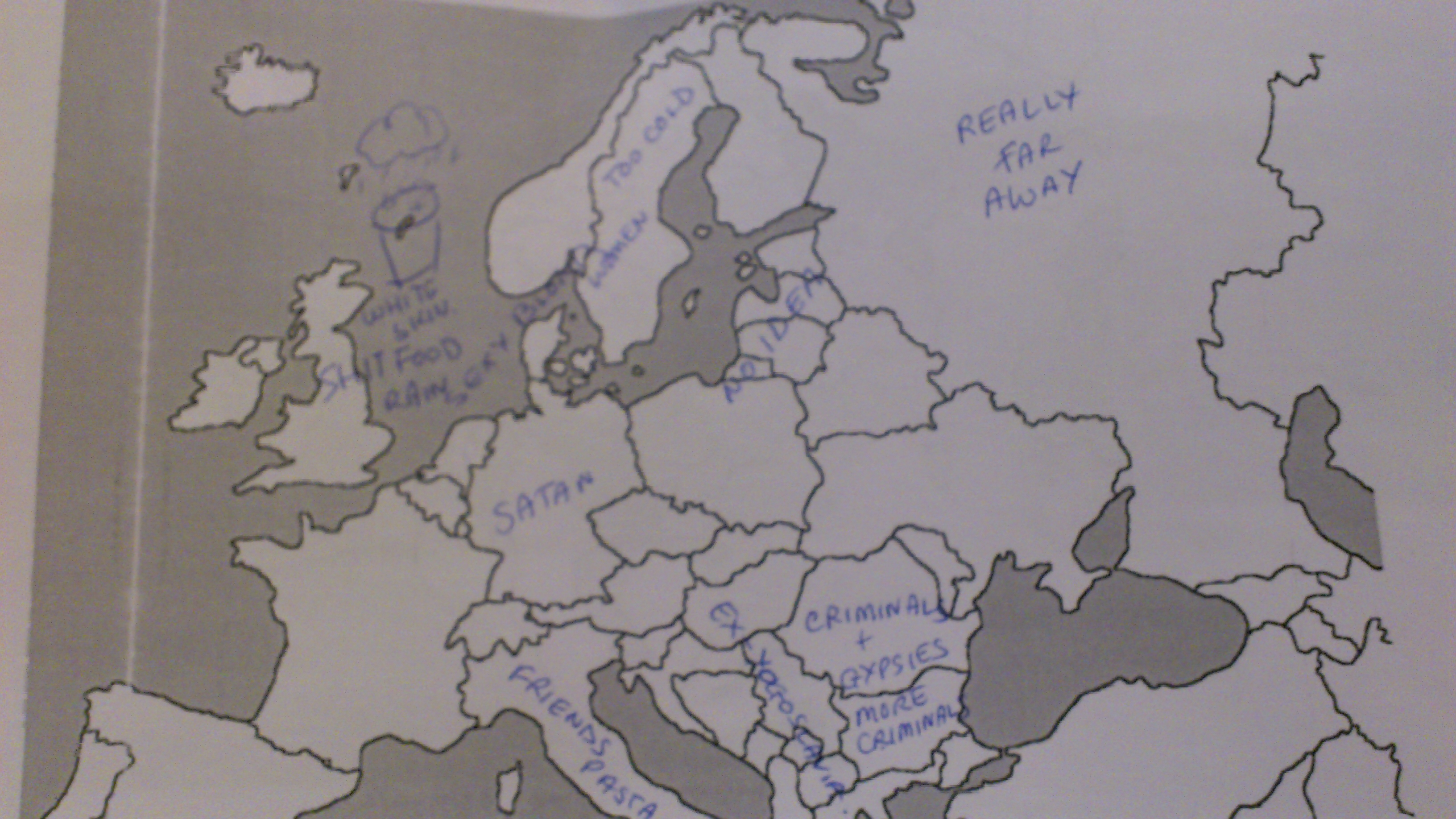
Here, for example, is a map created by some of the delegates at the TESOL Spain event at which this lesson was first presented. There was little time to complete the map and the photography is shocking, but you’ll get the idea:
And here is the ‘official’ version:

from http://alphadesigner.com/mapping-stereotypes/
There are some nice points of comparison which you can have your students highlight to you. Germany is singled out for abuse in both cases, and there is an almost equally disparaging tone for Romanians and Bulgarians – they are either low-skilled workers or “criminals”. Interestingly, Britain is seen from the perspective of a Spanish tourist in the first map, and from that of a Spanish host in the second. Italians are viewed more positively in the first than in the second, and the sexual attractiveness of Scandinavian women wins out over tax regimes in the first map.
8. It should be fairly straightforward from this point to coax your students towards more in-depth discussion of these issues. Here are some possible discussion questions to get things started:
- Which of the stereotypes that you’ve seen do you feel are particularly accurate, or not, in describing that country? Are Italians more ‘mama’s boys’ or ‘friends’ in relation to Spain?
- Which of the national perspectives represented do you feel are fair or unfair? Are Latin Americans really so obsessed with dancing? Do Germans really view Europe as a storehouse to serve its own needs? How do you feel about the way your own country is viewed?
- Is the characterisation of Germany as cruel a long-standing stereotype, or perhaps a reaction to more recent events? Are any of the other stereotypes you saw like this?
- Would you consider any of these stereotypes harmful? Can they be characterised as racist?
- Have you ever been treated in a stereotyped way, when travelling or talking to foreigners? How did you feel about it?
- Do you ever argue with people who speak in a stereotyped way about other nationalities?
As ever in such discussions, there is a danger of intolerant or even racist attitudes being expressed. Each teacher will handle this in his/her own way, and indeed will have their own limits of tolerance; my tendency is not to directly prohibit any point of view, but rather to let the group handle it (unless, of course, you have a particularly intolerant or racist group, in which case you would probably give this lesson a wide berth anyway). In extreme cases, intervention may be required on your part, but beware of imposing too rigid a definition of what can and cannot be said in the classroom. Often, a simple appeal to reason – e.g. ‘Would you be saying that if someone of that nationality was in the class?’ – can be enough to draw attention to the boundary between acceptable and unacceptable. As I once told a particularly memorable trainee – we’re here to teach English, not values. How far it’s possible to separate these notions may be a juicy topic for another time.
Meantime, if you liked these maps, there are various prints and atlases available – that’s right, you guessed it – from the Alphadesigner website.

I think this is such a creative way to talk about stereotypes. What a fun way as well to think about my ow. I’d like to add a suggestion: How about asking students to create a map of Europe according to my own experience? I always say to my children that it takes just one person you know to make a stereotype obsolete. So in my own experience Spain will become Out of Her Way (because the first time I went to Seville a woman on the bus went out of her way, literally, to show me what I should see and what restaurants to try.) Of course, if you’ve never met a German, that’s not easy to do, as unlikely as that is though.
Another idea could be to ask students to fill the map with inventions or achievements. They’ll have to put in the work there and find out about other – maybe as a project over a week. I wouldn’t want to just leave it at the negative side of stereotypes. I’ve had really nasty comments to deal with whenever I talked about stereotypes. Not that I can change the world in my English classes… 🙂
Thanks for your comment and suggestion! It really is an interesting idea. However, I can imagine two problems – first, as you already highlight, that your Ss would need to be sufficiently well-traveled or to have met people from other countries to be able to make a judgement based on experience. Secondly, that they may have met someone who only confirmed the stereotypical idea they had! Sometimes we only find what we expect to find …
Another thing to consider is that positive views of a nationality can be equally stereotypical and perhaps even racist. Here in Catalonia, Scots are generally viewed positively, but as a result of the movie Braveheart – i.e. we are proud, independent and passionate. But this makes us seem like all heart and no head, and is therefore equally as reductive as the English stereotype of Scots as mean or tight-fisted.
Regarding the Germans, I have no difficulty in imagining a non-stereotypical one as I am half German on my mother’s side! I sometimes think that the very anti-German stereotypes you find in the UK stem not only from history, but from a disavowal of the many characteristic similarities between Germans and Brits!
What might get your class away from stereotyped thinking is using a video or text which gets behind stereotypes. Here’s quite a light-hearted one, aimed at adults, but which could be exploited nicely – here is the stereotype – can the Ss think of arguments against it? Then they can read on and check predictions: http://www.yoshke.com/2009/01/top-10-national-stereotypes/
Thanks for your response. My suggestion was just really meant as an extension. And yes, it doesn’t work in all teaching contexts. I’ve taught on residential courses here in England that are very much sold on the idea you make friends from other countries. I still find it astonishing, still, to hear remarks like “Spanish people are dirty” from intelligent, well-travelled young Italians.
But that just as an aside – I love your lesson as it is
Oh dear, so much for European integration! I hear similar things from some Spanish people about the French! The English used to say the same about the Irish … and on it goes.
All we can do as teachers, as you say, is point out alternative ways of thinking, or ask questions to get this process rolling. The rest is too much to fight against … and as I said in the post, I would warn anyone against using this lesson with students who have very ingrained views like that – it may bring out the worst in them! But you’ve got me thinking – we need a stereotype-busting lesson!
Thanks again for your comments, they are much appreciated, and I’m glad you like the lesson!
Thank you! I will use yet another one of your Maps lesson… my advanced student loves them 🙂
I personally love the stereotype maps of the US or of US views of the world… and especially of California – because some of them are soooo true. awful but good.
Thank you again!
I am sorry to point it out, but here is a mistake in the translation. “Pútria” is a fusion of the concept “patria” (country) with the word “puta” (prostitute), so that “Madre pútria” can be actually translated as Mother cuntry.
A complete explanation can be found in the web page: http://news360x.fr/reflexions-geopolitiques-sur-lespagne-3-les-perspectives-actuelles/
[4] Dans la rhétorique traditionnelle des dirigeants latino-américains, les nations hispanophones d’Amérique constituent les « républiques sœurs » (repúblicas hermanas), tandis que l’Espagne est la « mère patrie » (madre patria). Les secteurs les plus opposés à l’influence de Madrid sur le continent parlent volontiers de madre putria, jeu de mots qui consiste à fusionner le terme patria et le mot puta.
Don’t be sorry Edvardo, you make a good point, although I’ll defend the text by saying there’s no mistake in the translation. I said it was untranslatable which I mean in the literal sense. “Mother cuntry” is great but not an exact translation as “cunt” and “whore” don’t mean the same thing at all, and “la patria” isn’t really “country” but “homeland”. However I accept that a creative translation like the one you suggest will do the job!